For August’s Map of the Month, the Utah Broadband Project is sharing maps made for use at the Governor’s Native American Summit, which took place August 14-15, 2013 at Utah Valley University in Orem, Utah.
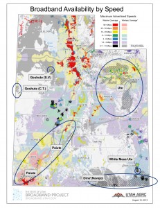
Broadband Availability by Speed with Tribal Areas: This map uses the Project’s statewide speed map, which is updated every 6 months. Areas owned by tribes are overlaid on maximum advertised residential download speeds.
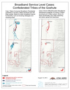
Broadband Service Level Cases on Tribal Lands: For May 2013′s Map of the Month, the Project created maps showing three different levels of broadband service, and the populated areas with/without access to those three levels. This month’s maps show the first two levels of service (basic broadband and home office/education broadband) specifically on tribal lands.
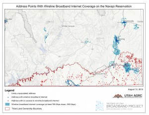
Address Points Served by Wireline Broadband on the Navajo Reservation: The Utah Broadband Project’s mapping team works with local counties to create address points (addresses with a latitude and longitude). For broadband mapping, address points assist in broadband coverage verification and identifying un-served and under-served addresses. This map highlights addresses in southern San Juan county with and without access to wireline broadband internet.
The Project Team Hosted a booth at the Summit and spoke with tribal representatives about participating in Regional Broadband Planning Councils. The team hopes to continue working with Utah’s tribes to address broadband needs.
All the maps above are good examples of how the Project’s mapping team can customize existing datasets to highlight the broadband landscape in certain areas of the state. If you are a part of the Regional Broadband Planning Councils or are another broadband stakeholder and are interested in creating similar maps, contact Jessie Pechmann at jpechmann@utah.gov.