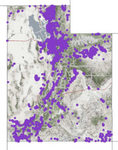

Utah’s 1,182,944 address points (12/20/17)
Our December 2017 Map of the Month highlights Utah’s statewide “Address Point” map layer — a vital, statewide information asset. The Address Point map layer is a collection of all of the addressed properties in Utah, known to, and shared by county government.
But wait! Don’t go away just yet, as the story and impact of Utah’s Address Points has broad implications and appeal for broadband and beyond. It is, however, appropriate to mention right away that this data asset, at a state-level owes its beginning to the Broadband Outreach Center and the initial state broadband mapping and planning grant efforts led and administered by the Utah Public Service Commission.
It’s actually hard to imagine now that an open, map-enabled address list only existed in a few Utah cities prior to the small state-to-county grants that kicked off this statewide initiative in 2013. Utah was a leading state in bringing address information together then, and, even now, only about half the states have a complete or maturing resource like this.

Rooftop address points in new area of Spanish Fork
First, and foremost relating to broadband, the addressed properties represent the primary collection of locations from which fixed technology broadband services are likely to be demanded. As Utah looks to complete the last connections to unserved and under-served residential and commercial locations, this data layer has been an excellent, precise guide. For this reason, we’ve been using it as a ‘basis’ Utah broadband metrics since 2015 that has resulted in interesting broadband service indicators over like this and this. The next best resource might be Census block-level data but it is much coarser (polygon areas), aging (2010), and excludes any commercial information.
Second, this dataset is extremely valuable to the emergency and disaster response process. Being able to pinpoint and verify the addresses of 911 callers, for example, can save minutes in directing law, fire, and EMS resources. And, in 911, saving just seconds can save lives. That importance is increasing. An address point map layer is in the process of being added to NENA’s (the 911 professional association) map data requirements for Next Generation 911. It’s great that Utah is well-ahead of the curve.
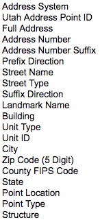
A list of attributes that can be submitted for each addressed property
Third — and of particular relevance and importance looking forward — the address point dataset will be one of the key resources used to get Utah best-prepared for a full census count in 2020. While there is not a 100% direct link in all cases, it is estimated that over $600 billion dollars per year is distributed by federal programs back to states, based on the population and demographic information that the Census Bureau gathers. Utah’s share of this is over $1,000 per capita per year. One of the best ways to ensure Utah gets its share, is to assist the Bureau in updating its internal database of addresses to which Census forms, instructions, and followup visits will be directed.
To this end, Utah is participating at both state and local government levels to make sure the the Census Bureau’s Master Address File is as complete as possible as they plan and execute their enumeration process. The address list review process, called the Local Update of Census Addresses (LUCA) will take place over a 4 month window in Spring of 2018.
There are many other applications areas that include elections, sales tax, services delivery, and economic development. The work that many of Utah’ counties are doing to expand the address point content to include “sub-address” information, like apartment, unit, and suite numbers, will further improve the value of the dataset across all of the uses mentioned above.
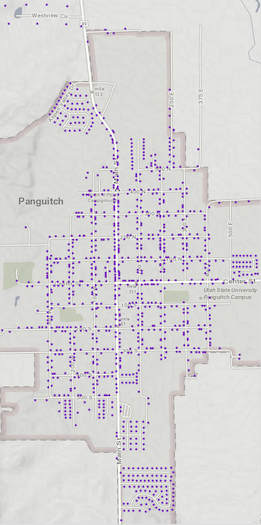
Panguitch, Utah (pop 1,481 in 2010) expressed as address points
All additions and changes that are received from counties are published monthly by Utah’s Automated Geographic Reference Center (AGRC), for download and/or online use. The entire data-sharing process is completely voluntary. But, as it continues to work successfully, this seems to indicate that the local data stewards and their organizations understand the value that they are creating and passing along, much of which flows back to their communities.
Because Utah’s address point layer is freely available, this allows anyone — from citizens to agencies to industry — to put this resource to work. Addresses exist so humans can better find and relate locations. That’s a critical function. Now that computers and GPS-enabled devices that rely on geographic coordinates are so involved in day-to-day location finding and routing, it makes sense that this digital data that links human-defined addresses to exacting latitude and longitude values is appropriately shared all the way up to the leading entities in the digital location economy like Google, Apple, Uber/Lyft, Here, MapBox, etc.
For questions about the Utah Address point layer and how it can be used, please contact agrc@utah.gov.