Pdf Map
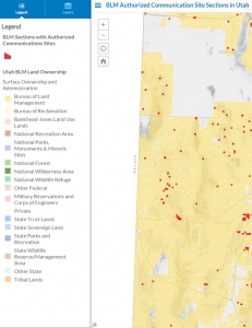
Interactive Map
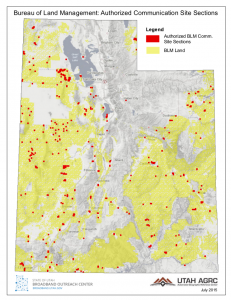
The Bureau of Land Management (BLM) has authority and a formal process to authorize communications sites on land that it owns. Many of Utah’s radio, TV, and broadband delivering antenna towers are located on BLM land.
This month’s map is interactive (click to open) and shows the Public Lands Survey System (PLSS) sections containing sites authorized by the BLM under the Federal Land Policy and Management Act (FLPMA) and other authorities. After examining this dataset against the statewide 6″ aerial photography, many, but not all, of the sections depicted appear to have active communication sites within their boundary. An existing site usually indicates the presence of electricity and the presence of microwave availability.
Here’s how this map was made. Authorized sites are tracked within the Bureau’s LR2000 land records database. The Broadband Outreach Center requested and received from the BLM a table of authorized communications site locations. The Center’s mapping team at AGRC was then able to automate a match between the PLSS section ID associated with each site in the BLM database and the PLSS section polygon in Utah’s State Geographic Information Database
As we rely more on wireless devices for communications, efficient siting of communication towers become increasingly important, especially in rural Utah. This map can assist with facility siting and coverage planning by showing where the BLM has already authorized communications infrastructure.
To learn more about broadband coverage and speeds in Utah, click on the Utah Broadband Map.