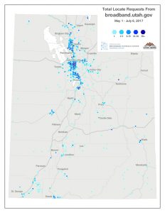
Residential Map Provider Requests Density May 1 – July 6 2017
Over 6 years ago the Utah Broadband Outreach Center first released the state’s Residential Broadband Map (original KSL press release).
Since then, Utah’s over 60 broadband providers have worked with the Broadband Outreach Center to provide up to date maps of broadband coverage and speeds so that residential users can discover and compare internet options at any given location in the state.
This month we look at how and where visitors to the site are using the residential broadband map, over a recent 2 month period (May 1 to June 6, 2017), to obtain broadband information.
The residential map enables users to view the list of broadband providers available at any location specified by address or map click. The site’s web analytics allow us to map the number of location-specific broadband inquiries which we have generalized to hexagon grid cells.
In general, the requests follow population density, but there are some outliers. Areas near Bear Lake, Kanab, Duchesne, Moab and an area along a remote stretch of I-70 are examples of areas of higher interest than might be anticipated.
The map request count for our 2 month period can also be viewed as tables aggregated by place name or by county. Murray, Orem, Salt Lake City, and newly incorporated Millcreek city lead the place name request list.
Analytics (below) for the entire site show almost 4,000 unique users of the site in the last year. The majority of visitors to the site are new users.

User analytics from July 1, 2016 – July 1, 2017.
For more information on the broadband availability data collected for the residential map, see this handout.