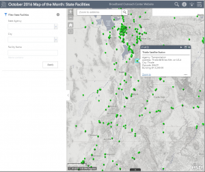
Click to open interactive state facilities map
The State of Utah owns buildings, sites, and other facilities in order to provide services across the state. Transportation, wildlife management, parks and recreation, and education, are just some of the missions that necessitate facilities operation. And of course, these are not only in the population centers of Utah, but also in some of the most rural parts of the state. Many of these facilities, but not all, require broadband internet to perform their duties sufficiently. State facilities, together with others operated by local government (K12 schools, libraries, etc), very often serve as anchor tenants for broadband service, creating the initial incentives for providers to bring higher speed and capacity to local communities.
Our October map of the month is an interactive map of these State of Utah owned facilities. The facility locations map layer was created through a partnership between the Utah Division of Facilities Construction and Management and Utah Division of Risk Management to better manage state assets, and contains facilities that are owned by the State of Utah. After opening the map and zooming to an area of interest, click on a location point for a popup of a facility’s details. To filter by state agency, city, or any other keyword search, open the tab on the left. Other map tools are also available in the upper right, such as a print option and basemap selector. Please note the map does not show leased facilities or those operated by the National Guard.